The outing at Gunung Rajah on Saturday 16 July 2016 was a combination of three sub-activities: trail running, trekking and camping. The trail running group would set the markers and they would attempt to arrive at the peak; the trekking group would only arrive at Hijau Campsite, while the camping group would camp at Hijau Campsite and ascend to the peak the following morning.
After a few rounds of group photos, we started from the car park of Chamang waterfall at 7:23 a.m., and the cut-off time for all to observe was 1:00 p.m. (campers excluded). We passed by the following landmarks: (a) end of earth-based road, (b) stream crossing, (c) Naning campsite, (d) Hijau Campsite.
Do CLICK HERE to view photos courtesy of yours truly (KC Leong).

Main group photo; another five members started 45 minutes earlier
Leading the pack, I was very cautious as I was relying on the memory of my maiden trip in August 2012 – four years ago! In that maiden attempt, I accompanied a trail runner who injured herself, and I could only manage to arrive at Hijau Campsite.
Along the journey, the team members enthusiastically asked questions about the terrain, the time required to arrive at the next landmark, etc. We arrived at Hijau Campsite at 11:00 a.m., questions about the peak were asked and I quipped that I could not answer as I have never gone beyond that point :-)

Members of camping group
Arriving at the bottom of the huge rockface, I checked that it was 12:30 p.m. – 30 minutes to the cut-off time for descent. Before that, at the bongsai area where there was a clear view of the vertical rockface and the peak, we estimated that the timing from the rockface to the peak would take another 45 min or 1 hour.
We noticed that the rain clouds started looming quickly over the peak as it has been raining at Bentong for the past few days. We decided to descend the mountain and tried again another time; after all, the mountain is always there. On a lighter note, at least that attempt was another step closer to the peak of Gunung Rajah.

Start of jungle trail (end of earth-based road)
After descending the mountain at around 5:00 p.m., at the entrance area where the ranges were permanently stationed in makeshift tents, one of the trekkers chatted with the rangers. With the lightning monitoring devices connected to the peak, we were told that lightning struck the peak at 1:25pm. Wow! That was closed! Imagine that if we had proceeded to the peak – the timing would have been perfect for a fatal encounter!

Stream crossing area
Stream crossing – this steam crossing is dangerous during raining season. When it rains, the water level would rise quickly impassable for return. And trekkers would be stranded for hours until the water had receded. Try to imagine that if one does not bring rain gear, sufficient food, or headlamp and the sky is getting dark.

At Naning campsite
We need to re-strategize in order to arrive at the peak – it is better to start from the trailhead at 6:00 a.m. It takes about 45 minutes to reach the end of the earth-based road, and the sky would be bright enough to enter the trails.
Mandatory items to bring – barring any unforeseen circumstances, good headlamp is a must. It is an anxiety to those who are waiting at the car park for their friends to return when the sky is getting dark and their friends still have not emerged from the jungle.

We arrive at Hijau campsite at 11:00 a.m.
My analysis on camping – if one needs to go to the peak, it is better to camp at Hijau campsite; however, if one just wants to enjoy the camping and the water activities, it is better to camp at Naning campsite (a lower ground which is another 1 hr 15 min to Hijau campsite).

The bongsai area - the peak and the rockface could be seen from here
Trekking permit – entering into the Gunung Rajah trails require one to pre-apply permit from the Pejabat Hutan Daerah Bentong. The rangers are permanently stationed there to check on the validity of entry. The process of applying permit is cumbersome, but it is a control environment as to how many or who-is-who are entering the forest. While meeting another group of trekkers, they even knew that we were the 30 trekkers from Kuala Lumpur. We hope that the Pejabat can make use of the latest technology to simplify the application and payment process.

The bottom of the the huge rockface ... we descended the mountain from here (Dphany and Ann Chua)
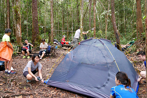
When we returned to Hijau campsite at around 1:30 p.m., the camping group had just arrived and busy pitching tents

A group photo with the camping group before we bid farewell to our friends. When descending the mountain, half hour later, it started to rain. The rain lasted for almost 3 hours

We adjouned to Bentong town for a sumptuos dinner
Landmark and Timing (moderate pace):
1. Arriving at the end of earth-based road (from carpark) – 45 min
2. Arriving at stream crossing – 1 hr
3. Arriving at Naning campsite – 45 min
4. Arriving at Hijau campsite – 1 hr
5. Arriving at rockfact point (require rope for ascent) – 1 hr 15 min
6. Final ascent to the peak – 1 hr
Time for ascent: about 5 hr 45 min
Note: (1) and (2) are run-able; (3) to (6) more of trekking.
Descending from rockface to car park - 4 hr 30 min
Total time: Start at 7:23 a.m., return to car park at 5:15 p.m.
Posted by KC Leong
No comments:
Post a Comment